Hiking Experience - Nordic Walking
- 66-Seen Wanderweg
- Altm�hltal-Panoramaweg
- Ausoniusweg
- Seensteig
- Burgenwanderweg / Naturpark Hoher Fl�ming
- Der Donauberglandweg
- Eifelsteig
- Elb-H�henweg
- Fr�nkischer Gebirgsweg
- Frankenwald Burgenweg
- Gipfelwanderweg Suhl
- Goethewanderweg Ilmenau
- Goldsteig
- Gr�nG�rtel Rundwanderweg
- Harzer-Hexen-Stieg
- Hermannsh�hen
- Der Hochrh�ner
- Kellerwaldsteig
- Kyffh�userweg
- Losheimer Felsenweg
- M�hlensteig
- Mosel.Erlebnis.Route
- Der Oberlausitzer Bergweg
- Der Rennsteig
- Die elf Traumpfade
- Rheinsteig
- Der Rothaarsteig
- S�chsische Schweiz Malerweg
- Saar-Hunsr�ck-Steig
- Der Schluchtensteig
- Schw�bische Alb-Nordrandweg
- Sintfeld-H�henweg
- Spessartwege 1 & 2
- Talsperrenweg Zeulenroda
- Uplandsteig
- Vogtland Panorama Weg
- Themenwanderweg „Von Bach zu Goethe“
- Vulkanring Vogelsberg
- Weinwanderweg Rhein-Nahe
- Weserberglandweg
- Westerwaldsteig
- Westweg
- Winterberger Hochtour
Contact (Route)
TOURIST INFORMATION WINTERBERGD-59955 Winterberg
Telefon 0 29 81 / 92 50 0
Contact
Deutscher WanderverbandWilhelmsh�her Allee 157-159
D-34121 Kassel
Tel.: +49 (0)561-93873-0
E-Mail: [email protected]

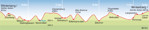
Winterberger Hochtour
Length, Start/End
82km, circular tour from Mount Kahler Asten or Winterberg
Highest elevation: 843m
Altitude profile
Service
82km, circular tour from Mount Kahler Asten or Winterberg
Highest elevation: 843m
Altitude profile
Service
Stages
| 1. | Winterberg - Siedlinghausen | 20,2 km |
| 2. | Siedlinghausen - Gr�nebach | 21 km |
| 3. | Gr�nebach - Z�schen | 17,7 km |
| 4. | Z�schen - Langewiese | 22,9 km |
| 5. | Langewiese - Winterberg | 9,6 km |
Highlights
- discover a holiday region
North Rhine-Westphalia
Sauerland
Historic towns Sauerland
Winterberg
Oranier Route
Schmallenberg / Bad Fredeburg
National Park Kellerwald-Edersee
FIS World Cup Ski Jumping, Willingen
North Rhine-Westphalia
Sauerland
Historic towns Sauerland
Winterberg
Oranier Route
Schmallenberg / Bad Fredeburg
National Park Kellerwald-Edersee
FIS World Cup Ski Jumping, Willingen
Tip
Stand beside the white cross that marks the summit of Clemensberg and watch the sun set over the “thousand hills of the Sauerland”. A chance to reflect on life or savour a romantic moment.
Stand beside the white cross that marks the summit of Clemensberg and watch the sun set over the “thousand hills of the Sauerland”. A chance to reflect on life or savour a romantic moment.
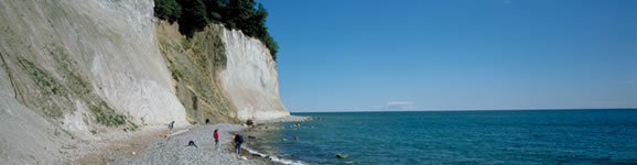
Westphalia's highest circular trail
The Winterberger Hochtour begins and ends at the foot of Mount Kahler Asten, passes through the districts of Winterberg, continues over the highest peaks in the Upper Sauerland region and crosses eight valleys. The natural beauty and cultural heritage along the way are truly memorable. Skirting around the town, the trail explores all aspects of the diverse surrounding countryside.
From the market square in Winterberg, the Hochtour and Rothaarsteig ascend Mount Kahler Asten together, passing beneath the St. Georg ski jump and the ice channels of the bobsleigh and toboggan run. They then wind their way up to what is without doubt the highest point in North Rhine-Westphalia, if you climb up to the platform on top of the observation tower. In fine weather, the panoramic views reach as far as Kassel, the Ruhr region and across the Rothaargebirge hills.
The Winterberger Hochtour then passes the source of the river Lenne, affording magnificent views across Hunau towards Altastenberg. Meadows give way to forest on the way to Sillbach, before the trail heads down the valley to Siedlinghausen. This is followed by the sweat-inducing climb up Hoher Hagen hill at Niedersfeld and a further climb up Clemensberg hill. The white cross on the summit marks where the route meets the Uplandsteig and Rothaarsteig. The three trails run together for a while, then the Hochtour then heads off to Z�schen via Hildfeld, Gr�nenbach and Elkeringshausen. This is followed by a taxing ascent to the Mount Ziegenhelle observation tower at an altitude of 816 metres before you set off back to Winterberg.
Travel Planner
Select an option...
Quality-certified trail
Travel Information
Public
transport: Winterberg is on the InterRegio rail network with direct
services from Dortmund, Hagen and Kassel. Winterberg offers regional
bus services to many of the towns along the trail, with some
interconnecting buses.
Weather
 Berlin
21.2 °F, heavy clouds Bremen
26.6 °F, bright Dresden
28.4 °F, dull weather-
D�sseldorf
32 °F, heavy clouds  Erfurt
21.2 °F, cloudy-
Frankfurt
28.4 °F, heavy clouds -
Hamburg
23 °F, bright -
Hannover
28.4 °F, cloudy -
Kiel
24.8 °F, bright -
Cologne
32 °F, heavy clouds -
Magdeburg
28.4 °F, bright -
Mainz
28.4 °F, heavy clouds -
Munich
28.4 °F, cloudy  Potsdam
23 °F, fog Saarbr�cken
30.2 °F, snow shower-
Schwerin
15.8 °F, bright -
Wiesbaden
28.4 °F, heavy clouds