Skip to content
Skip to navigation
Skip to subnavigation
Skip to search
Skip to content
Skip to navigation
Skip to subnavigation
Skip to search

Hiking Experience - Nordic Walking
- 66-Seen Wanderweg
- Altm�hltal-Panoramaweg
- Ausoniusweg
- Seensteig
- Burgenwanderweg / Naturpark Hoher Fl�ming
- Der Donauberglandweg
- Eifelsteig
- Elb-H�henweg
- Fr�nkischer Gebirgsweg
- Frankenwald Burgenweg
- Gipfelwanderweg Suhl
- Goethewanderweg Ilmenau
- Goldsteig
- Gr�nG�rtel Rundwanderweg
- Harzer-Hexen-Stieg
- Hermannsh�hen
- Der Hochrh�ner
- Kellerwaldsteig
- Kyffh�userweg
- Losheimer Felsenweg
- M�hlensteig
- Mosel.Erlebnis.Route
- Der Oberlausitzer Bergweg
- Der Rennsteig
- Die elf Traumpfade
- Rheinsteig
- Der Rothaarsteig
- S�chsische Schweiz Malerweg
- Saar-Hunsr�ck-Steig
- Der Schluchtensteig
- Schw�bische Alb-Nordrandweg
- Sintfeld-H�henweg
- Spessartwege 1 & 2
- Talsperrenweg Zeulenroda
- Uplandsteig
- Vogtland Panorama Weg
- Themenwanderweg „Von Bach zu Goethe“
- Vulkanring Vogelsberg
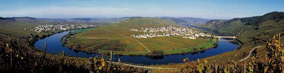
- Weinwanderweg Rhein-Nahe
- Weserberglandweg
- Westerwaldsteig
- Westweg
- Winterberger Hochtour
Contact (Route)
Projektb�ro Sintfeld-H�henwegK�nigstrasse 16
D-33142 B�ren
Telefon +49 (0)2951 970175

Contact
Deutscher WanderverbandWilhelmsh�her Allee 157-159
D-34121 Kassel
Tel.: +49 (0)561-93873-0
E-Mail: [email protected]

Sintfeld-H�henweg
Length, Start/End
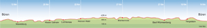
144km, circular route starting at B�ren (or any of the other stops)
Highest elevation: 428m
Altitude profile
Service
144km, circular route starting at B�ren (or any of the other stops)
Highest elevation: 428m
Altitude profile
Service
Stages
| 1. | B�ren - Wewelsburg | 13 km |
| 2. | Wewelsburg - Lichtenau Kloster Dalheim | 25 km |
| 3. | Lichtenau-Kloster Dalheim - Hebram Wald | 22 km |
| 4. | Hebram Wald - Blankenrode | 27 km |
| 5. | Blankenrode - Bad W�nnenberg | 27 km |
| 6. | Bad W�nnenberg - Ringelstein | 16 km |
| 7. | Ringelstein - B�ren | 14 km |
Highlights
- discover a holiday region
North Rhine-Westphalia
Teutoburg Forest
Oranier Route
Weser Renaissance Route
Westphalian Museum of Abbey Culture Dalheim
Klostergarten Dalheim
Bad Driburg
North Rhine-Westphalia
Teutoburg Forest
Oranier Route
Weser Renaissance Route
Westphalian Museum of Abbey Culture Dalheim
Klostergarten Dalheim
Bad Driburg
Tip
The B�ren one-day walking festival takes place every year on the first Sunday in May. This locally organised event features walks from 5km to a marathon 42km on the Sintfeld-H�henweg.
The B�ren one-day walking festival takes place every year on the first Sunday in May. This locally organised event features walks from 5km to a marathon 42km on the Sintfeld-H�henweg.
Nature & heritage in the southern Paderborner Land region
The Sintfeld-H�henweg trail offers magnificent natural scenery and fascinating cultural heritage. This 144km long-distance circular tour is an attractive way of enjoying the cultural and natural riches of the southern Paderborner Land region.
Gently undulating countryside draped with forests, meadows and fields is the hallmark of the Sintfeld region. You need to look more closely before you notice the traces of thousands of years of history. South of Paderborn, the Sintfeld-H�henweg rises over the Karst plateau - fascinating for botanists, birdwatchers and geologists - and guides you to the many attractions found between the Egge hills and the Westphalian basin. Sparse forests, highland moors and heathland are interspersed with a surprisingly diverse cultural heritage. Opened in 2007, the excellently signposted route visits megalithic burial sites and prehistoric graves, Virgin Mary pilgrimage sites and castles. A fine example of the latter is the Wewelsburg, the only one in Germany with a triangular layout.
Close to Herbram-Wald and Essentho, the Sintfeld-H�henweg joins the Eggeweg to give hikers in the Sintfeld hills a taste of premium-grade walking.
Travel Planner
Select an option...
Travel Information
Public
transport: National trains to Paderborn, from there express bus
service to B�ren, Bad W�nnenberg and Lichtenau. All other stops on
the route can be reached from Paderborn and from each other using
scheduled bus services.
Car: A33 / A44 to the W�nnenberg / Haaren intersection, then take the Bad W�nnenberg exit. On the A44 take the B�ren exit or the Marsberg / Meerhof exit towards Lichtenau. From the A33 take the Borchen / Etteln exit towards Lichtenau.
Car: A33 / A44 to the W�nnenberg / Haaren intersection, then take the Bad W�nnenberg exit. On the A44 take the B�ren exit or the Marsberg / Meerhof exit towards Lichtenau. From the A33 take the Borchen / Etteln exit towards Lichtenau.
Weather
 Berlin
21.2 °F, heavy clouds Bremen
26.6 °F, bright Dresden
28.4 °F, dull weather-
D�sseldorf
32 °F, heavy clouds  Erfurt
21.2 °F, cloudy-
Frankfurt
28.4 °F, heavy clouds -
Hamburg
23 °F, bright -
Hannover
28.4 °F, cloudy -
Kiel
24.8 °F, bright -
Cologne
32 °F, heavy clouds -
Magdeburg
28.4 °F, bright -
Mainz
28.4 °F, heavy clouds -
Munich
28.4 °F, cloudy  Potsdam
23 °F, fog Saarbr�cken
30.2 °F, snow shower-
Schwerin
15.8 °F, bright -
Wiesbaden
28.4 °F, heavy clouds