Skip to content
Skip to navigation
Skip to subnavigation
Skip to search
Skip to content
Skip to navigation
Skip to subnavigation
Skip to search

Hiking Experience - Nordic Walking
- 66-Seen Wanderweg
- Altm�hltal-Panoramaweg
- Ausoniusweg
- Seensteig
- Burgenwanderweg / Naturpark Hoher Fl�ming
- Der Donauberglandweg
- Eifelsteig
- Elb-H�henweg
- Fr�nkischer Gebirgsweg
- Frankenwald Burgenweg
- Gipfelwanderweg Suhl
- Goethewanderweg Ilmenau
- Goldsteig
- Gr�nG�rtel Rundwanderweg
- Harzer-Hexen-Stieg
- Hermannsh�hen
- Der Hochrh�ner
- Kellerwaldsteig
- Kyffh�userweg
- Losheimer Felsenweg
- M�hlensteig
- Mosel.Erlebnis.Route
- Der Oberlausitzer Bergweg
- Der Rennsteig
- Die elf Traumpfade
- Rheinsteig
- Der Rothaarsteig
- S�chsische Schweiz Malerweg
- Saar-Hunsr�ck-Steig
- Der Schluchtensteig
- Schw�bische Alb-Nordrandweg
- Sintfeld-H�henweg
- Spessartwege 1 & 2
- Talsperrenweg Zeulenroda
- Uplandsteig
- Vogtland Panorama Weg
- Themenwanderweg „Von Bach zu Goethe“
- Vulkanring Vogelsberg
- Weinwanderweg Rhein-Nahe
- Weserberglandweg
- Westerwaldsteig
- Westweg
- Winterberger Hochtour
Contact (Route)
Tourist Information SuhlTouristik und Congress GmbH
Friedrich-K�nig-Strasse 7
D-98527 Suhl
Telefon +49 (0)3681 720052

Contact
Deutscher WanderverbandWilhelmsh�her Allee 157-159
D-34121 Kassel
Tel.: +49 (0)561-93873-0
E-Mail: [email protected]

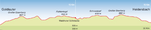
Gipfelwanderweg Suhl
Length, Start/End
30km, Goldlauter - Heidersbach
Highest elevation: 984m
Altitude profile
Service
30km, Goldlauter - Heidersbach
Highest elevation: 984m
Altitude profile
Service
Stages
| 1. | Goldlauter - Suhler H�tte / Waldhotel Schm�cke | 15 km |
| 2. | Suhler H�tte / Walhotel Schm�cke - Goldlauter-Heidersbach | 15 km |
Highlights
- discover a holiday region
Thuringia
Thuringian Forest
German Toy Road
Towns in Thuringia
Erfurt
Thuringia
Thuringian Forest
German Toy Road
Towns in Thuringia
Erfurt
Tip
Schneekopf (978 m)
The Schneekopf, the second-highest mountain in the Thuringian Forest, is volcanic in origin and commands breathtaking views that stretch far into the distance. An observation tower opened in June 2008 raises the altitude to 1,000 metres, thus further improving the panorama.
Schneekopf (978 m)
The Schneekopf, the second-highest mountain in the Thuringian Forest, is volcanic in origin and commands breathtaking views that stretch far into the distance. An observation tower opened in June 2008 raises the altitude to 1,000 metres, thus further improving the panorama.
Ticking off the peaks in the Thuringian Forest
A route marked out on the central ridge of the Thuringian Forest that lines up breathtaking natural beauty and glorious panoramic views as the mountains fall one after another. The trail runs for 30 kilometres from Goldlauter to Heidersbach.
Since September 2006, this quality-assured route has given avid hikers the chance to conquer seven peaks of 900 metres of more over a distance of just 30 kilometres. The magnificent seven are Grosser Eisenberg (902m), Grosser Finsterberg (944m), Fichtenkopf (944m), Sachsenstein (915m), Schneekopf (978m), Rosenkopf (939m) and Grosser Beerberg (982m). An exciting prospect for walkers who love a challenge. Hiking along the main wooded ridge of the Thuringian mountains has much to recommend it: stunning views from two observation towers and rocky forest crags, flower-filled meadows, crystal-clear springs and four places to grab a bite to eat along the way.
The Gipfelwanderweg Suhl is a fantastic way to get close to nature. Less than 2 per cent of the track is surfaced with man-made materials, so you don't have to worry about monotonous stretches of forest road. On the summit of the Schneekopf - which was a restricted military area until 1990 - a broad mountain plateau has been restored to its natural splendour, offering stunning views in all directions.
Travel Planner
Select an option...
Quality-certified trail
Travel Information
Arrival
Car: A71 from Erfurt or Schweinfurt or A73 from Coburg to Suhl.
Public transport: Train services from Erfurt to W�rzburg (RegionalExpress) and Erfurt to Meiningen (RegionalBahn) stop at Suhl main station. Continue on local bus services D1 or D2 to the "Rosenau" stop.
Departure
Car: Towards the A71 and A73 via Suhl.
Public transport: Buses from the "Stockmar-Platz" to Suhl main train station.
Weather
 Berlin
21.2 °F, heavy clouds Bremen
26.6 °F, bright Dresden
28.4 °F, dull weather-
D�sseldorf
32 °F, heavy clouds  Erfurt
21.2 °F, cloudy-
Frankfurt
28.4 °F, heavy clouds -
Hamburg
23 °F, bright -
Hannover
28.4 °F, cloudy -
Kiel
24.8 °F, bright -
Cologne
32 °F, heavy clouds -
Magdeburg
28.4 °F, bright -
Mainz
28.4 °F, heavy clouds -
Munich
28.4 °F, cloudy  Potsdam
23 °F, fog Saarbr�cken
30.2 °F, snow shower-
Schwerin
15.8 °F, bright -
Wiesbaden
28.4 °F, heavy clouds