Skip to content
Skip to navigation
Skip to subnavigation
Skip to search
Skip to content
Skip to navigation
Skip to subnavigation
Skip to search

Hiking Experience - Nordic Walking
- 66-Seen Wanderweg
- Altm�hltal-Panoramaweg
- Ausoniusweg
- Seensteig
- Burgenwanderweg / Naturpark Hoher Fl�ming
- Der Donauberglandweg
- Eifelsteig
- Elb-H�henweg
- Fr�nkischer Gebirgsweg
- Frankenwald Burgenweg
- Gipfelwanderweg Suhl
- Goethewanderweg Ilmenau
- Goldsteig
- Gr�nG�rtel Rundwanderweg
- Harzer-Hexen-Stieg
- Hermannsh�hen
- Der Hochrh�ner
- Kellerwaldsteig
- Kyffh�userweg
- Losheimer Felsenweg
- M�hlensteig
- Mosel.Erlebnis.Route
- Der Oberlausitzer Bergweg
- Der Rennsteig
- Die elf Traumpfade
- Rheinsteig
- Der Rothaarsteig
- S�chsische Schweiz Malerweg
- Saar-Hunsr�ck-Steig
- Der Schluchtensteig
- Schw�bische Alb-Nordrandweg
- Sintfeld-H�henweg
- Spessartwege 1 & 2
- Talsperrenweg Zeulenroda
- Uplandsteig
- Vogtland Panorama Weg
- Themenwanderweg „Von Bach zu Goethe“
- Vulkanring Vogelsberg
- Weinwanderweg Rhein-Nahe
- Weserberglandweg
- Westerwaldsteig
- Westweg
- Winterberger Hochtour
Contact (Route)
Donaubergland Marketing und Tourismus GmbHBahnhofstrasse 123
D-78532 Tuttlingen
Telefon +49 (0)7461 7801675

Contact
Deutscher WanderverbandWilhelmsh�her Allee 157-159
D-34121 Kassel
Tel.: +49 (0)561-93873-0
E-Mail: [email protected]

Der Donauberglandweg
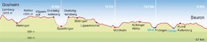
Length, Start/End
67km (incl. access), Gosheim (Lemberg) - Beuron an der Donau
Highest elevation: 1,015m
Altitude profile
Service
67km (incl. access), Gosheim (Lemberg) - Beuron an der Donau
Highest elevation: 1,015m
Altitude profile
Service
- Altitude profile as PDF
- Donauberglandweg, von Lemberg nach Beuron | GPS Tracks (gpx) | © Deutscher Wanderverband
Stages
| 1. | Gosheim - Spaichingen | 20 km |
| 2. | Spaichingen - M�hlheim a.d.D. | 18 km |
| 3. | M�hlheim a.d.D. - Fridingen/Donau | 13,5 km |
| 4. | Fridingen/Donau - Beuron-Kloster | 16 km |
Highlights
- discover a holiday region
Baden-W�rttemberg
Swabian Alb
Culture of the Swabian Alb
Swabian Alb Route
Stuttgart
Baden-W�rttemberg
Swabian Alb
Culture of the Swabian Alb
Swabian Alb Route
Stuttgart
Tip
The TuWass thermal spa and pool complex in Tuttlingen is one of the most popular attractions in the region, while the open-air museum in Neuhausen ob Eck takes visitors on a journey into the past.
The TuWass thermal spa and pool complex in Tuttlingen is one of the most popular attractions in the region, while the open-air museum in Neuhausen ob Eck takes visitors on a journey into the past.
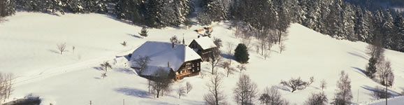
Across the peaks of the Swabian Alb to the Danube
Certified as a Wanderbares Deutschland premium trail at the CMT travel fair in Stuttgart in January 2008, the Donauberglandweg is rapidly becoming one of Germany's favourite hikes. The trail starts as it means to go on, with an ascent up Lemberg hill. After a steep zigzag climb, it joins the Schw�bische Alb Nordrandweg (HW1) on to its way to the summit. Sadly, there is no suitable rock or cliff to provide any views from what is the highest mountain in the Swabian Alb, unlike on the rest of the route. Instead, 152 steps lead up Lemberg tower, which does offer panoramic views of the Black Forest from Mount Hornisgrinde to Mount Feldberg, of almost the entire Swabian Alb and on a clear day also the Alps, from Mount Zugspitze to the Bernese Alps.
Following the edge of the Swabian Alb to the Danube
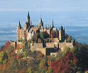
After a slight detour via Wehingen, near Gosheim the Donauberglandweg (Danube Peaks Trail) reaches the 1,001-metre-high panoramic vantage point at the top of Mount Kehlen, where the route encounters the Albtrauf, the steep rock face running along the entire western side of the Alb plateau, which rises suddenly more than 300 metres above the foothills. Here, the trail also rejoins the Schw�bische Alb Nordrandweg (HW1), running along the edge of the Albtrauf where stunning views follow in quick succession. Together with the HW1, the trail continues to Klippeneck hill, a gliders' favourite, and Dreifaltigkeitsberg hill overlooking Spaichingen, where a pilgrimage church stands on the peak of a prehistoric sun-worshipping site. Descend via a beautiful "way of the cross" to the town of Spaichingen at the bottom of the hill. This is the overnight stop. The next day the route continues through B�ttingen and past Lippach mill through the idyllic Lippach valley towards the Danube as far as M�hlheim.
Upper Danube Nature Park
In the heart of the Upper Danube nature reserve, the Donauberglandweg links the riverside villages of M�hlheim and Fridingen. Both have old quarters graced by fine medieval houses and each has a stately residence of greatly differing style. In between the two lies a spectacular section of the trail leading across Gelber Fels (Yellow Crag) and Stephansfels. Visitors can explore the world underneath them on guided tours through M�hlheim cave and Kolbingen cave. Already impressive up to this point, the landscape assumes a more dramatic character from Fridingen onwards as the trail heads through the southern tributary valleys of Germany's largest river gorge outside the Alps: spectacular rock formations at the Knopfmacherfels and Stiegelesfels outcrops and some final uphill and downhill stretches make the last section to Beuron a sheer delight.
Travel Planner
Select an option...
Quality-certified trail

Travel Information
Arrival
Public transport: Nearest train station is Spaichingen on the line from Tuttlingen to Rottweil. Bus service to Gosheim (www.zugbus-rab.de).
Car: A81 Stuttgart - Singen, Rottweil exit or A14 towards Spaichingen, L433 to Gosheim.
Departure
Public transport: Naturparkexpress from Beuron towards Tuttlingen / Donaueschingen or Ulm for InterCityExpress / InterRegio connections.
Car: L277 towards Tuttlingen / A81 towards Sigmaringen, B311 to Ulm (A8).
Weather
 Berlin
21.2 °F, heavy clouds Bremen
26.6 °F, bright Dresden
28.4 °F, dull weather-
D�sseldorf
32 °F, heavy clouds  Erfurt
21.2 °F, cloudy-
Frankfurt
28.4 °F, heavy clouds -
Hamburg
23 °F, bright -
Hannover
28.4 °F, cloudy -
Kiel
24.8 °F, bright -
Cologne
32 °F, heavy clouds -
Magdeburg
28.4 °F, bright -
Mainz
28.4 °F, heavy clouds -
Munich
28.4 °F, cloudy  Potsdam
23 °F, fog Saarbr�cken
30.2 °F, snow shower-
Schwerin
15.8 °F, bright -
Wiesbaden
28.4 °F, heavy clouds