Hiking Experience - Nordic Walking
- 66-Seen Wanderweg
- Altm�hltal-Panoramaweg
- Ausoniusweg
- Seensteig
- Burgenwanderweg / Naturpark Hoher Fl�ming
- Der Donauberglandweg
- Eifelsteig
- Elb-H�henweg
- Fr�nkischer Gebirgsweg
- Frankenwald Burgenweg
- Gipfelwanderweg Suhl
- Goethewanderweg Ilmenau
- Goldsteig
- Gr�nG�rtel Rundwanderweg
- Harzer-Hexen-Stieg
- Hermannsh�hen
- Der Hochrh�ner
- Kellerwaldsteig
- Kyffh�userweg
- Losheimer Felsenweg
- M�hlensteig
- Mosel.Erlebnis.Route
- Der Oberlausitzer Bergweg
- Der Rennsteig
- Die elf Traumpfade
- Rheinsteig
- Der Rothaarsteig
- S�chsische Schweiz Malerweg
- Saar-Hunsr�ck-Steig
- Der Schluchtensteig
- Schw�bische Alb-Nordrandweg
- Sintfeld-H�henweg
- Spessartwege 1 & 2
- Talsperrenweg Zeulenroda
- Uplandsteig
- Vogtland Panorama Weg
- Themenwanderweg „Von Bach zu Goethe“
- Vulkanring Vogelsberg
- Weinwanderweg Rhein-Nahe
- Weserberglandweg
- Westerwaldsteig
- Westweg
- Winterberger Hochtour
Contact (Route)
Westerwald Touristik-ServiceKirchstrasse 48a
D-56410 Montabaur
Telefon +49 (0)2602 30010

Contact
Deutscher WanderverbandWilhelmsh�her Allee 157-159
D-34121 Kassel
Tel.: +49 (0)561-93873-0
E-Mail: [email protected]

Westerwaldsteig
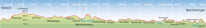
Length, Start/End
235km, Herborn - Bad H�nningen
Highest elevation: 657m
Altitude profile
Service
235km, Herborn - Bad H�nningen
Highest elevation: 657m
Altitude profile
Service
Stages
| 1. | Herborn - Breitscheid | 15,5 km |
| 2. | Breitscheid - Fuchskaute | 13 km |
| 3. | Fuchskaute - Rennerod | 15 km |
| 4. | Rennerod - Westerburg | 17 km |
| 5. | Westerburg - Dreifelden | 20,5 km |
| 6. | Dreifelden - Nistertal | 13,5 km |
| 7. | Nistertal - Bad Marienberg | 8 km |
| 8. | Bad Marienberg - Hachenburg | 14,5 km |
| 9. | Hachenburg - Limbach | 11 km |
| 10. | Limbach - Kloster Marienthal | 20 km |
| 11. | Kloster Marienthal - Weyerbusch | 17,5 km |
| 12. | Weyerbusch - Flammersfeld | 14,5 km |
| 13. | Flammersfeld - Horhausen | 15 km |
| 14. | Horhausen - Peterslahr/Oberlahr | 8,5 km |
| 15. | Peterslahr/Oberlahr - Neustadt-Kodden | 9 km |
| 16. | Neustadt-Kodden - Waldbreitbach | 18 km |
| 17. | Waldbreitbach - Arienheller | 13 km |
Highlights
- discover a holiday region
Rhineland-Palatinate
Hessen
Westerwald
German Limes Route
The Legendary Rhine-Romantic-Route
Oranier Route
UNESCO World Heritage the Limes
Rhineland-Palatinate
Hessen
Westerwald
German Limes Route
The Legendary Rhine-Romantic-Route
Oranier Route
UNESCO World Heritage the Limes
Tip
St�ffel Fossil Park explores the tertiary period of Earth's history and doubles up as an industrial heritage site. The crater lake dates back 25 million years, and the interactive learning areas give you the chance to climb fixed rope routes, get involved in a number of hands-on activities, visit exhibitions and go on guided tours. Close to Stockum-P�schen, Enspel and Nistertal.
St�ffel Fossil Park explores the tertiary period of Earth's history and doubles up as an industrial heritage site. The crater lake dates back 25 million years, and the interactive learning areas give you the chance to climb fixed rope routes, get involved in a number of hands-on activities, visit exhibitions and go on guided tours. Close to Stockum-P�schen, Enspel and Nistertal.
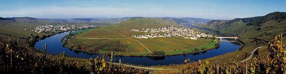
Water, woods and wondrous views
The Westerwaldsteig is a top-quality walking route that opened in May 2008. As it makes its way through the Westerwald Forest from the Rhine to the River Dill, the trail keeps its promise of water, woods and wondrous views.
The 235km trail meanders through gorges and geoparks, stops at enchanting little medieval towns and passes endless sights and attractions: the idyllic lakes of the Kroppacher Schweiz region, magnificent abbeys and secluded countryside chapels, mighty castles overlooking the Wied river, old-fashioned mills and stunning vantage points in the upper reaches of the forest. There are six nature parks in Rhineland-Palatinate and Hessen where excellent walks enjoy top priority. The Westerwaldsteig offers a workout for both mind and body with its short stages, wide variety of diversions en route and fascinating daily destinations.
Travel Planner
Select an option...
Quality-certified trail

Travel Information
Arrival
Public transport: By train on the Rhine route to Rheinbrohl and then bus no. 370 to Arienheller.
Car: Via the A61 (Sinzig) and B42 to Rheinbrohl-Arienheller.
Departure
Public transport: By train from Herborn heading for Betzdorf/Cologne, Ruhr area (Ruhrgebiet) or Rhine-Main.
Car: Join the A61 at Herborn.
Weather
 Berlin
21.2 °F, heavy clouds Bremen
26.6 °F, bright Dresden
28.4 °F, dull weather-
D�sseldorf
32 °F, heavy clouds  Erfurt
21.2 °F, cloudy-
Frankfurt
28.4 °F, heavy clouds -
Hamburg
23 °F, bright -
Hannover
28.4 °F, cloudy -
Kiel
24.8 °F, bright -
Cologne
32 °F, heavy clouds -
Magdeburg
28.4 °F, bright -
Mainz
28.4 °F, heavy clouds -
Munich
28.4 °F, cloudy  Potsdam
23 °F, fog Saarbr�cken
30.2 °F, snow shower-
Schwerin
15.8 °F, bright -
Wiesbaden
28.4 °F, heavy clouds