Hiking Experience - Nordic Walking
- 66-Seen Wanderweg
- Altm�hltal-Panoramaweg
- Ausoniusweg
- Seensteig
- Burgenwanderweg / Naturpark Hoher Fl�ming
- Der Donauberglandweg
- Eifelsteig
- Elb-H�henweg
- Fr�nkischer Gebirgsweg
- Frankenwald Burgenweg
- Gipfelwanderweg Suhl
- Goethewanderweg Ilmenau
- Goldsteig
- Gr�nG�rtel Rundwanderweg
- Harzer-Hexen-Stieg
- Hermannsh�hen
- Der Hochrh�ner
- Kellerwaldsteig
- Kyffh�userweg
- Losheimer Felsenweg
- M�hlensteig
- Mosel.Erlebnis.Route
- Der Oberlausitzer Bergweg
- Der Rennsteig
- Die elf Traumpfade
- Rheinsteig
- Der Rothaarsteig
- S�chsische Schweiz Malerweg
- Saar-Hunsr�ck-Steig
- Der Schluchtensteig
- Schw�bische Alb-Nordrandweg
- Sintfeld-H�henweg
- Spessartwege 1 & 2
- Talsperrenweg Zeulenroda
- Uplandsteig
- Vogtland Panorama Weg
- Themenwanderweg „Von Bach zu Goethe“
- Vulkanring Vogelsberg
- Weinwanderweg Rhein-Nahe
- Weserberglandweg
- Westerwaldsteig
- Westweg
- Winterberger Hochtour
Contact (Route)
RothaarsteigPostfach 2205
D-57382 Schmallenberg
Hotline 0180 - 5154555 (14 Ct./min / dt. Festnetz)
Contact
Deutscher WanderverbandWilhelmsh�her Allee 157-159
D-34121 Kassel
Tel.: +49 (0)561-93873-0
E-Mail: [email protected]

Der Rothaarsteig
Length, Start/End
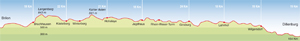
154km / 187km (via Fuchskaute), Brilon - Dillenburg
Highest elevation: 843m
Altitude profile
Service
154km / 187km (via Fuchskaute), Brilon - Dillenburg
Highest elevation: 843m
Altitude profile
Service
Stages
| 1. | Brilon - Bruchhausen | 18 km |
| 2. | Bruchhausen - K�stelberg | 17 km |
| 3. | K�stelberg - Hoheleye | 21 km |
| 4. | Hoheleye - Jagdhaus | 18 km |
| 5. | Jagdhaus - Ginsburg | 24 km |
| 6. | Ginsburg - Lahnhof | 18 km |
| 7. | Lahnhof - Wilgersdorf-Kalteiche | 19 km |
| 8. | Wilgersdorf-Kalteiche - Dillenburg | 19 km |
| 9. | W1 Wilgersdorf-Kalteiche - Fuchskaute | 26,5 km |
| 10. | W2 Fuchskaute - Dillenburg (Bhf.) | 26 km |
Highlights
- discover a holiday region
North Rhine-Westphalia
Sauerland
Westerwald
Winterberg
FIS World Cup Ski Jumping
Oranier Route
North Rhine-Westphalia
Sauerland
Westerwald
Winterberg
FIS World Cup Ski Jumping
Oranier Route
Tip
Latrop is the starting point of one of the loveliest circular walks along the Rothaarsteig, and you don't even need to leave the trail itself. The trail's main route along the ridge of the hills and the alternative valley route through the Upper Sauerland run parallel to each other for around 13 kilometres. The main route starts from the walkers' car park in Latrop and leads you through the Grubental valley to the pagan altar stone, then onto the town of Schanze and up to the ridge. You stay on the ridge from Heidenstock hill to Millionenbank hill where the route descends back to Latrop.
Latrop is the starting point of one of the loveliest circular walks along the Rothaarsteig, and you don't even need to leave the trail itself. The trail's main route along the ridge of the hills and the alternative valley route through the Upper Sauerland run parallel to each other for around 13 kilometres. The main route starts from the walkers' car park in Latrop and leads you through the Grubental valley to the pagan altar stone, then onto the town of Schanze and up to the ridge. You stay on the ridge from Heidenstock hill to Millionenbank hill where the route descends back to Latrop.
Exploring the land of a thousand hills
The Rothaarsteig trail begins in Brilon and continues for 154 kilometres across the Rothaargebirge hills to the Upper Westerwald region and to the town of Dillenburg. A gently rolling landscape is characteristic of the "land of a thousand peaks and valleys" between North Rhine-Westphalia and Hessen. The trail follows the watershed between the Rhine and Weser rivers, passing the sources of several major rivers along the way: the Ruhr, Lenne, Sieg, Dill and Lahn all originate here and are headed towards the Rhine, while the Eder is on its way to join the Weser.
Rich in forests and traditions
Although the forests that gave their names to these hills were cleared over time, they have long since regrown. Coniferous woods and upland heaths in the north contrast with the lush beech forests that define the southern section of the route. The first stages of the trail lead through the rugged scenery of the Sauerland region, past no fewer than 15 peaks of 800 metres of more, just waiting to be climbed for panoramic views across to Westphalia and northern Hessen.
Thrills and relaxation
The Rothaarsteig trail offers both. Mount Ginsterkopf offers an especially adventurous ascent, while a good sense of balance is required on the rope bridge near K�hhude and a head for heights will be useful on the observation tower on Mount Kahler Asten, the Rhein-Weser tower and the circular tower that once belonged to the Ginsburg border fortress. However, there are also plenty of opportunities to relax for a bit and just enjoy the sunshine. If you want to get really comfortable, there is sure to be a lounger or a wooden bench at hand on which you can while away a few hours. None of the Rothaarsteig stages are particularly long and each one has plenty of places where you can adjourn your hike for the day. Public transport is excellent and many accommodation providers will pick you up and drop you back off again.
Travel Planner
Select an option...
Travel Information
Arrival
Public transport: Train from Kassel, Dortmund or Paderborn to Brilon (www.rlg-online.de)
Car: Via the A46/B7 from the Ruhrgebiet or via the A44/B7 from northern Hessen.
Departure
Public transport: From Dillenburg by train towards the Rhine-Main region or Siegen (www.rmv.de)
Car: On the A45 towards Frankfurt or the Olpe intersection.
Weather
 Berlin
21.2 °F, heavy clouds Bremen
26.6 °F, bright Dresden
28.4 °F, dull weather-
D�sseldorf
32 °F, heavy clouds  Erfurt
21.2 °F, cloudy-
Frankfurt
28.4 °F, heavy clouds -
Hamburg
23 °F, bright -
Hannover
28.4 °F, cloudy -
Kiel
24.8 °F, bright -
Cologne
32 °F, heavy clouds -
Magdeburg
28.4 °F, bright -
Mainz
28.4 °F, heavy clouds -
Munich
28.4 °F, cloudy  Potsdam
23 °F, fog Saarbr�cken
30.2 °F, snow shower-
Schwerin
15.8 °F, bright -
Wiesbaden
28.4 °F, heavy clouds